Please, log in to access all of the content of this page.
Since summer 2013, we study the topography of Lakes of Vendée where boating is permitted and where conditions permit to water our boat.
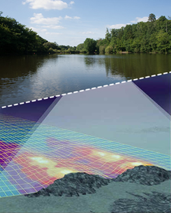
This bathymetric study is to probe the Lake at regular intervals and according to a precise mesh. The information collected is then retired to form a database. Depth and bottom structure indices thus collected, allow to edit maps topographic and sedimentological Lakes of Vendée.
Specifically, how it works and what interest you?
We are therefore at your disposal Vendée Lakes cards distributed by sectors (see list of the above areas: A, B, C, D, etc...).
Once your license is acquired, you access the area studied in the form of a map GoogleMap comprising both the topography of the Lake and of the bottom structure. He will then suffice to modify the left sliders (topography) and right (structure) to increase or decrease the opacity of the superimposed layers.
If you visit the site using a smartphone or a tablet pc equipped with a GPS sensor, it will be possible to locate you in real time on the map.
A measurement tool also lets you appreciate the distances between the Bank and the elements represented (ditches, River, dam, etc...).
This information in hand, you will be able to ask your bait or lure at the right place in these vast expanses of water. Locate accurately the ditches, rivers, but also silted areas, rocks or gravel barriers.